If you need to save money on your next trip, Google Maps just made it easier to plan routes accordingly if you prefer to take toll routes.
Google Maps has finally added the ‘estimated toll route’ feature, which gives you an estimated price for your planned trip when using toll routes. This comes after Google announced the feature back in 2021 when it was first reported by Android Police.
For the planner friend: this new feature is for you. 🙏
Now when you’re planning trips big and small, you can check estimated toll prices before you pick a route—and spend what you save on road snacks. pic.twitter.com/Lfy8s2TXQU
However, Google Maps is not the first app to offer this feature. Waze has been estimating toll route prices for a while before the feature landed on Google Maps.
The new feature will be added to Google Maps on iOS and Android, though there’s no confirmation yet on when it will be available in Canada right off the bat.
If you like to run, hike, or bike to get some fresh air, Google Maps’ new ‘Air Quality Index (AQI)’ layer might appeal to you.
Google Maps’ ‘Air Quality Index ‘ (AQI) overlay utilizes data collected from agencies such as the Environmental Protection Agency (EPA) in the U.S. to calculate air quality information. The feature is currently only available in the U.S., but it will likely make its way to Canada soon.
MobileSyrup has reached out to Google for more information.
As temperatures heat up and summer officially begins across the U.S., many of us are taking the opportunity to get outside. If you have an adventure on the horizon, here are two ways you can use our tools to stay safe and healthy this summer → https://t.co/qbVkou168r ☀️
PurpleAir will also offer a low-cost sensor network that detects conditions within hyper-local areas that appear on Google Maps. Air quality information from PurpleAir can be accessed on Nest smart displays and speakers.
Following the platform’s new ‘Air Quality Index’ feature, Google Maps also now offers a wildfire layer within the app to help users avoid areas that are at risk of or are experiencing wildfires. This feature was developed in partnership with the National Interagency Fire Center (NIFC).
Apple is adding Toronto and Vancouver to its new Google Maps update.
The new ‘city experience’ includes details on land, roads, transit, and driving navigation.
Users will also be able to access multi-stop routing to plan 15 stops in advance, including allowing drivers to ask Siri to add stops. Users will also be able to save previous routes to easily access in the future and plan trips on their Macs and send those routes to iPhones.
On transit, riders will be able to see fares and add transit cards to their wallet. Users with fairs running low will receive an alert to reload without leaving the Map app.
Google Maps’ Street View is getting a range of new features, marking the immersive view’s 15th year in existence since being introduced in 2007.
“Street View began as a far-fetched idea from Google co-founder Larry Page to build a 360-degree map of the entire world. Fast forward to today: There are now over 220 billion Street View images from over 100 countries and territories,” according to the blog post.
Today, Google is deploying a new Street View camera, bolstering the team currently comprised of the Street View Car and Street View Trekker.
Google’s new camera “takes all the power, resolution and processing capabilities that we’ve [Google] built into an entire Street View car, and shrinks it down into an ultra-transportable camera system that’s roughly the size of a house cat.”
The camera weighs less than 15lb (6.8kg) and is fully customizable with components like LiDar and laser scanners. Additionally, Google says that the new camera can be attached on top of any vehicle with a roof rack and can be operated from a smartphone, making the image-collection process easier for Google’s partners, especially in areas that haven’t been mapped significantly.
The new camera is expected to be spotted on roads next year.
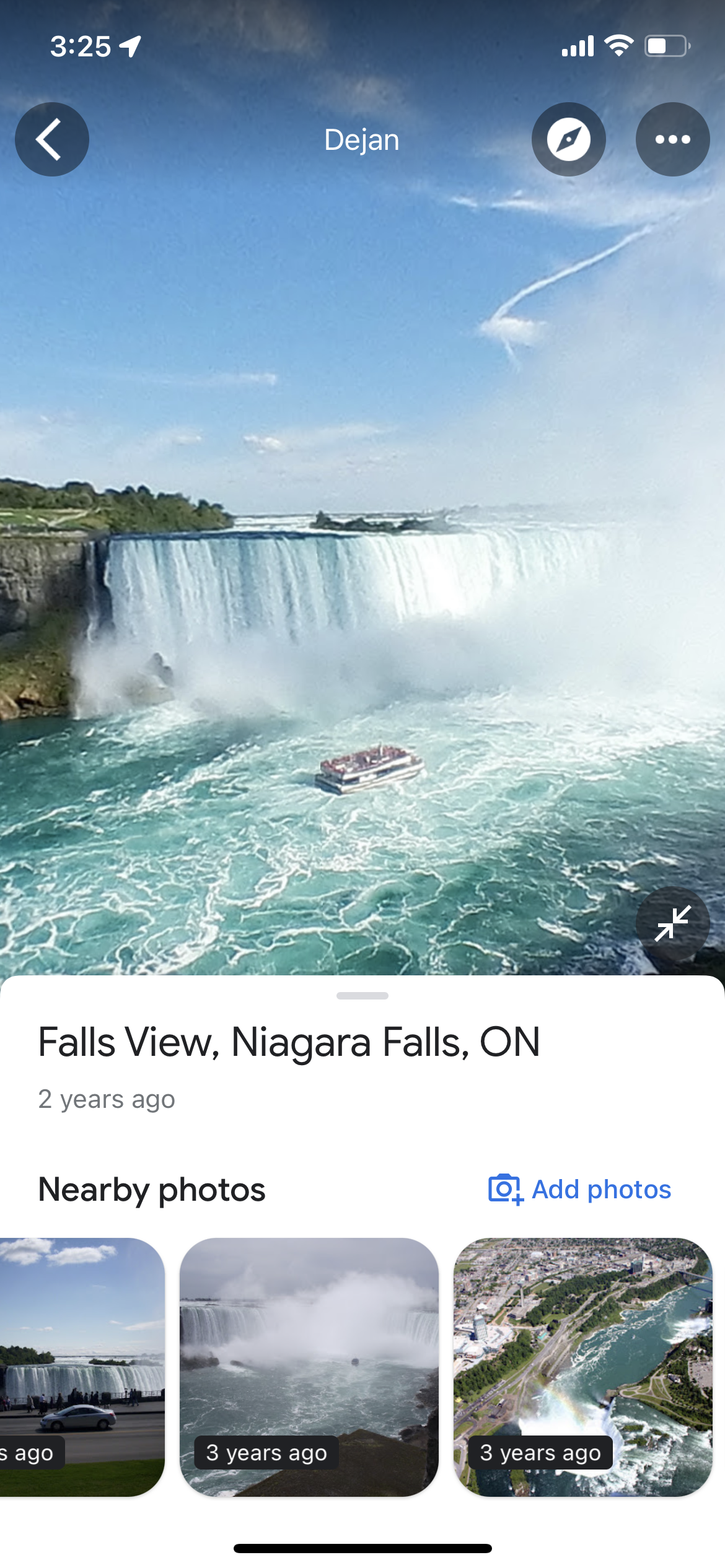
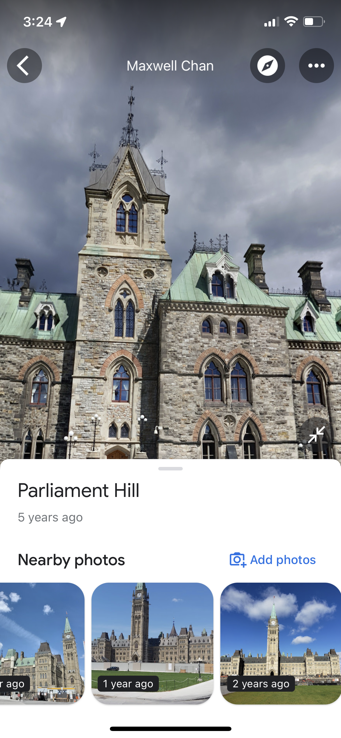
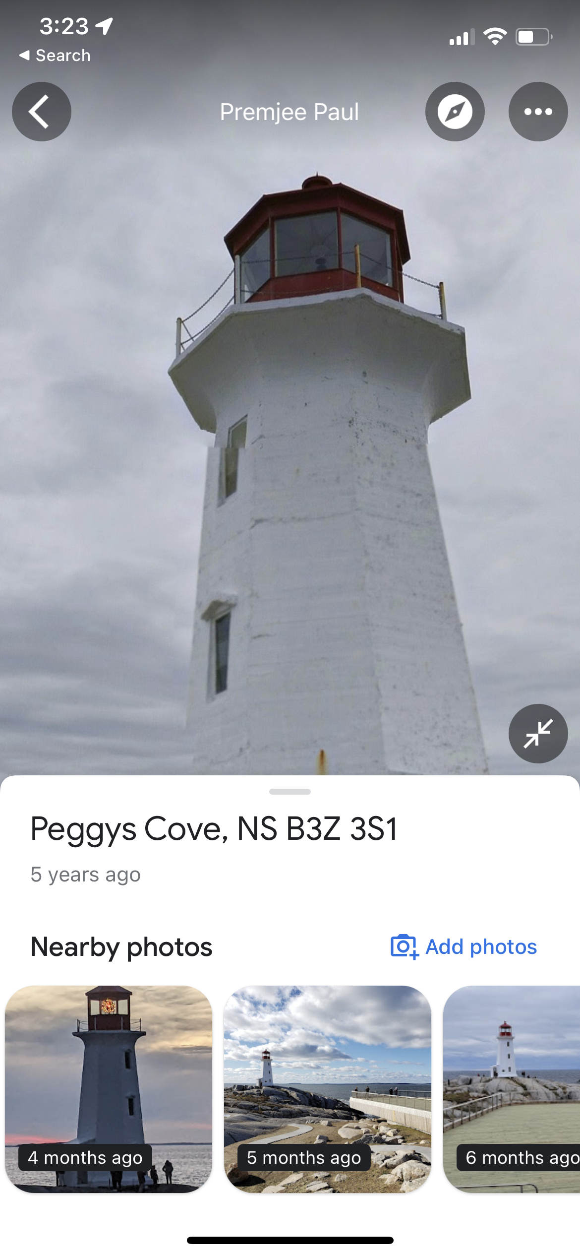
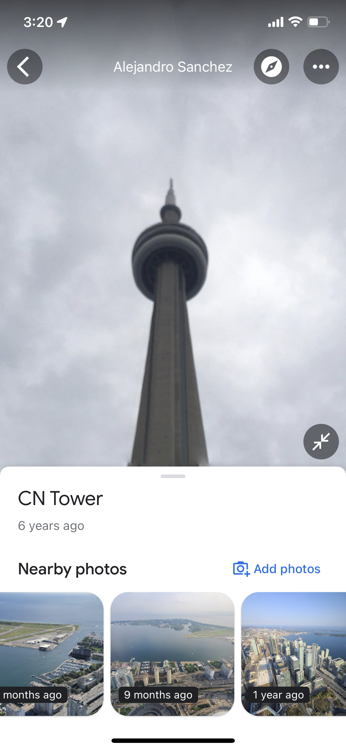
Additionally, the Street View feature will now let you travel back in time. Well, not really, but the feature will let you see how specific streets, monuments or areas of interest have changed over the years. The feature has always been available on Maps for Desktop but is now arriving on Google Maps for Android and iOS, and lets you check imagery of said places dating back to 2007.
To access the new feature, go into Street View of a location you want to explore and scroll up to reveal “Nearby photos.” You can then find photos of the place dating back to 2007, though in the case of some famous Canadian spots, I could only go as far back as three to four years.
Google also revealed some of the most iconic tourist attractions that garner the most clicks on Street View, including Miss Piggy plane wreck in Churchill, MB, CN Tower in Toronto, ON, and the Horseshoe falls in Niagara Falls, ON, whereas some top-clicked points of interest in Canada for art, history and culture were Casa Loma in Toronto, ON, Aga Khan Museum in North York, ON and Green Gables Heritage Place in Cavendish, PE.
Learn more about the upgrades coming to Street View and Google Maps over the coming months here.
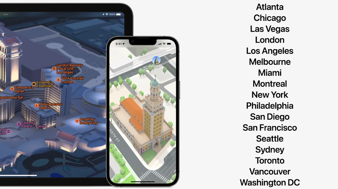
At I/O 2022, Google is bringing several new Maps features that fuse ‘Street View’ and ‘Live View.’ According to the tech giant, thanks to advances in computer vision AI, the company is able to fuse billions of images to create a new ‘Immersive View.’
Google says this is a new way to explore places you want to visit. With the feature, you’re able to soar over major cities and explore where you want to catch the sights, grab food and more. There’s also a ‘Time Slider’ feature that lets you look at the area around and check weather and traffic conditions throughout the day.
You can go down to street level and then check a nearby restaurant and even peek inside of the restaurant to look at the vibe. This feature will work on any device.
These features will launch in major cities like Los Angeles, London, New York, San Francisco and Tokyo by the end of the year.
Alongside this, Google Maps is launching a new AR Core Geospatial API to build new capabilities. The API brings Live View to developers for free. The Geospatial API will bring new features to games, parking apps, and more.
Google has launched a new Maps mobile app feature in Canada that aims to help drivers make more sustainable choices.
Called “eco-friendly driving,” the feature uses AI to analyze carbon emissions of your planned route and suggests alternative directions that would consume less fuel. The app takes into account traffic, road steepness and other variables.
As Google notes, nearly 20 percent of global CO2 emissions come from ground transportation, which was a key reason why this feature has been introduced.
Google Maps can be downloaded for free on Android and iOS.
Amid Russia’s illegal invasion of Ukraine, the Live traffic layer for Google Maps, in addition to information on how busy restaurants and stores are have currently been disabled for Ukraine, quoting safety concerns for locals.
According to Google, the move will deter the invaders from gathering the Ukrainian public’s location data, though people on the ground can still use live traffic information during turn-by-turn navigation sessions.
While a necessity to safeguard civilians, the same features were also proving to be helpful to pinpoint Russian convoy locations. Note that these are most likely civilians caught in long roadblocks or traffic jams, and not Russian soldiers driving along with smartphones in their pockets.
According @googlemaps, there is a “traffic jam” at 3:15 in the morning on the road from Belgorod, Russia to the Ukrainian border. It starts *exactly* where we saw a Russian formation of armor and IFV/APCs show up yesterday. Someone's on the move. pic.twitter.com/BYyc5YZsWL
Other big tech companies have also taken action against Russia, including Facebook and Tik Tok taking down Russian state media in Europe, YouTube blocking Russia’s state-owned media outlet RT from earning ad revenue and Elon Musk deploying Starlink to help Ukraninans stay connected to the internet.
Check out the full Reuters report about Google disabling live traffic features in Maps here.
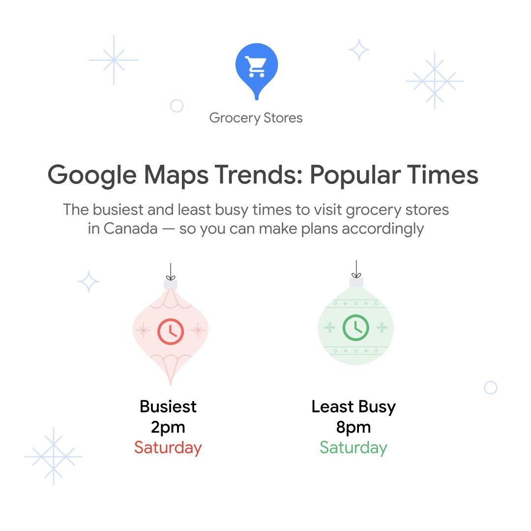
Google Maps is helping Canadians strategize their holidays by revealing user trends, including popular shopping times, food and even by adding new features.
According to Google Maps, the worst time to buy groceries is 2pm on Saturday and the best time to go is 8 pm on Saturday. Further, the best time to head to a large shopping mall is Thursday, and if people aren’t at the grocery store, apparently they’re shopping because the worst time to head to the mall is also Saturday at 2pm.
The best time to go to the airport if you’re leaving your home for the holidays is on a Friday evening and the busiest time is Saturday at noon.
Overall, the best time for a meal this holiday season is around 11am on Friday, and, as expected, the busiest time is Saturday evenings.
According to Google Maps, Chinese food was the most popular cuisine ordered on Christmas Eve. And on New Year’s Eve and New Year’s Day, Japanese food is the top search (oddly enough, last New Year’s Eve, I ordered sushi).
Google Maps has also listed the 10 most popular attractions, according to reviews:
Four Seasons Centre for the Performing Arts, Toronto
Elgin and Winter Garden Theatre Centre, Toronto
The Orpheum, Vancouver
Museum of Anthropology, Vancouver
Maison symphonique, Place des Arts, Montréal
Le Bordel Comédie Club, Montréal
Canadian War Museum, Ottawa
Canadian Museum of Nature, Ottawa
Heritage Park Historical Village, Calgary
Studio Bell, home of the National Music Centre, Calgary
Winspear Centre, Edmonton
Fort Edmonton Park, Edmonton
Finally, Google is adding a new Directory tab to Maps that aims to help users find their way around buildings, such as directions in a large shopping centre.
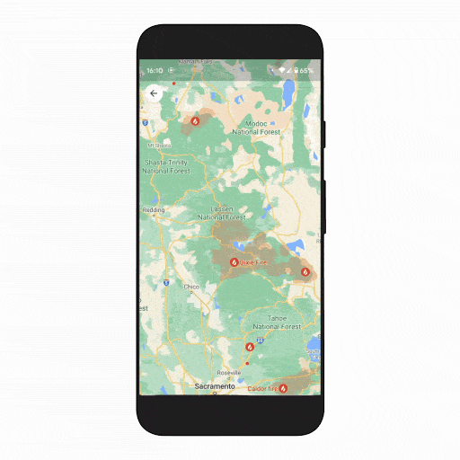
As part of a drive to make Google Maps more useful during emergency situations, the Mountain View, California-based company is making it simpler to locate the most up-to-date information regarding wildfires.
After launching a tool in late 2019 to help people track wildfires, Google has now added a new wildfire layer to its Google Maps, which users will be able to turn on and off to see the most up-to-date information on several wildfires at once.
“Just tap on a fire to see available links to resources from local governments, such as emergency websites, phone numbers for help and information, and evacuation details,” reads Google’s blog post about the new feature. “When available, you can also see important details about the fire, such as its containment, how many acres have burned, and when all this information was last reported.”
According to Google, the new wildfire tracking feature will roll out globally this week for Google Maps on Android, with iOS and desktop updates coming in October.
Further, Google states that the new feature will be expanded to cover additional fires and information regarding fires in the United States, courtesy of data from the National Interagency Fire Center (NIFC), with Australia following suit. Hopefully, a similar tie-up with the Canadian Interagency Forest Fire Centre (CIFFC) will result in Canadians getting the expanded feature as well, considering there are about 140 active wildfires in Canada right now.
CIFFC also has an interactive map of ‘Out of Control,’ ‘Being Held,’ and ‘Under Control’ wildfires, which you can check here.